Hanover (New Hampshire, United States). If, for the general public, archaeologists travel the world like Indiana Jones, those of the 21st century are as comfortable behind a keyboard as on dusty construction sites. An article published in November 2023 in the journal Antiquity from the University of Durham (Great Britain) illustrates the interest of military data in the context of archaeological research. Since the American government made public series of satellite images taken in the 1960s and 1970s around the world, three researchers from Dartmouth College (Hanover) have used them to identify sites in the Middle East which may or may not confirm a archaeological hypothesis from the 1930s.
At that time, precisely in 1934, appeared The Trace of Rome in the Syrian Desert, by Antoine Poidebard and René Mouterde, a work that has become a classic of archaeology. As Jesse Casana, David D. Goodman and Carolin Ferwerda recall in the introduction to their article, Poidebard, main author of the work, was convinced that the Romans had built a protective wall against the Persians on the border in the 2nd and 3rd centuries. eastern part of their empire: this is what he called the “Syrian limes” (in Latin limes designates a border established by humans). To demonstrate his hypothesis, Poidebard flew over the Syrian desert and took thousands of aerial photographs, a technique experimented with during the First World War. Antoine Poidebard was also a former pilot who became a priest after the war, and if he was able to fly freely in Syria, it was because he belonged to the 39th aviation regiment of the French Forces in the Levant (Syria was then placed under French mandate). His images revealed 116 Roman sites near the strata diocletianaa fortified road, the main axis of communication in Roman Syria, built in the 3rd century by Emperor Diocletian (284-305).
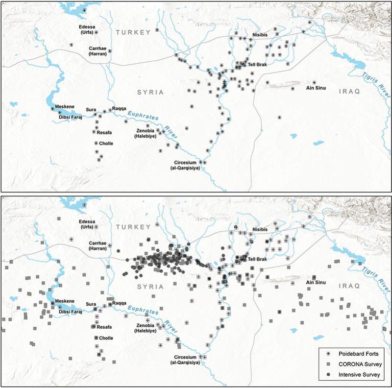
A and B: images obtained by the CORONA satellite in 1967 and 1968. C: image from the HEXAGON satellite dating from 1974. D: modern satellite image.
© US Geological Survey
Satellite images
Researchers will compare satellite images with those of Poidebard to verify whether the network of forts was a defensive wall. Several other hypotheses have in fact been formulated since 1934, which is why the three researchers examined the same area (300,000 km2). As the article explains, modern images come from two “American spy satellites”, Corona and Hexagon: they date from 1960 to 1986, a period when few Syrian sites were excavated outside urban areas. These high definition images compensate for the impossibility for Americans to go to Syria since 2013, when Poidebard was able to search certain sites himself. The article details the method, called “orthorectification”, which consists of firstly correcting the optical distortions of the images, then identifying all the Roman sites already known, in portions of 25 km2 (5 km by 5). This cutting uses the grid technique used on excavation sites. Then the researchers selected 10,000 sites “potentially new”based on morphological criteria: Poidebard had in fact created a typology of Roman sites, where squares of 50 to 100 m on a side were forts, and those of 100 to 200 m on a side, fortresses. Erosion, built structures or promontories (tell in Arabic) are all criteria for identifying these sites or eliminating them from the list. The researchers sorted the images by the time period they were taken because the sites are easier to spot “in late fall and early winter” due to the absence of agricultural crops.
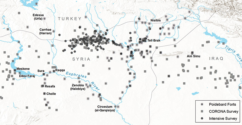
At the top, map of the forts listed by Poidebard. Below, the new forts identified by Jesse Casana, David D. Goodman and Carolin Ferwerda.
© Cambridge University Press
No defensive wall
Ultimately, 396 new Roman forts were discovered and confirmed, with a much wider distribution than those of Poidebard since they are present as far as north-west Iraq and Jordan. A study of sites in northern Iraq (Djezireh region) has also proven that the forts were aligned on a west-east axis between the hinterland of Aleppo and the Mosul region, and not on an axis from southwest to northeast as Poidebard wrote. For researchers, the latter suffered from “discovery bias” because he only inspected areas where he suspected Roman sites, and each discovery confirmed the existence of a limes. However, researchers also found new sites on the route of the strata diocletianawhile wondering about “a preservation bias” which would distort their work. The forts are in fact generally isolated, located in “marginal environments”, and they are subject to erosion and the effects of human activity: several sites identified by Poidebard had already disappeared by the time satellites photographed the desert.
In conclusion, researchers dispute the dating of the majority of sites to the 2nd and 3rd centuries, because in Iraq several sites identified by Poidebard actually date from the 12th and 13th centuries. And in Syria the Roman fortresses were often occupied until the Umayyads (661-750) by reconstructions. Finally, the distribution of forts in Syria and Iraq invalidates the hypothesis of a defensive wall, and leads researchers towards a buffer zone where caravans and troops could take shelter, far from raids by nomadic tribes.